


KERN COUNTY, Calif. (KERO — Firefighters are continuing to make progress in containing the Borel Fire. We're tracking the latest updates here.
WEDNESDAY 8/7 6:07 P.M. UPDATE:
Containment has grown, it is now at 84% per Watch Duty. Acres burned remains the same.
WEDNESDAY 8/7 11:45 A.M. UPDATE:
The Borel Fire is now at 79% containment and with acres burned still at 59,340 per Watch Duty.
TUESDAY 8/6 9:50 A.M. UPDATE:
The Borel Fire is now at 75% containment and has burned 59,340 acres per Watch Duty.
MONDAY 8/5 5:02 P.M. UPDATE:
The Red Cross announces that the evacuation centers set up for the Borel Fire have been closed.
MONDAY 8/5 10:12 A.M. UPDATE:
The Borel fire is now at 68% containment and has burned 59,340 acres per Watch Duty.
FRIDAY 8/2 5:45 A.M. UPDATE:
The Borel Fire is now 47% contained. Thursday night the fire had spread to 59,398 acres.
THURSDAY 8/1 4:15 P.M. UPDATE:
Per Watch Duty, the Borel Fire is now at 41% containment and has burned 59,225 acres.
THURSDAY 8/1 5:30 A.M. UPDATE:
As of Thursday morning, the Borel Fire is at 39% containment.
WEDNESDAY 7/31 10:20 A.M. UPDATE:
Watch Duty reports the Borel Fire is at 58,682 acres. Containment is at 34% Wednesday morning.
WEDNESDAY 7/31 8 A.M. UPDATE:
Watch Duty reports the Borel Fire has expanded to 58,682 acres. Containment remains at 22% Wednesday morning.
WEDNESDAY 7/31 5:30 A.M. UPDATE:
Reports on acreage burned and containment remain unchanged overnight.
TUESDAY 7/30 6:48 P.M. UPDATE:
The Borel fire is now at 57,548 acres and is at 22% containment per Watch Duty.
The same evacuation warnings and orders are in place. Check out the latest evacuation map on this website.
TUESDAY 7/30 6:17 P.M. UPDATE:
The Borel Fire is at 57,306 acres burned and is now at 17% containment, per the Kern County Fire Department.
The same evacuation warnings and orders are in place. Check out the latest evacuation map on this website.
TUESDAY 7/30 3:33 P.M. UPDATE:
According to Cal Trans, Highway 178 has been reopened. The road was closed down at the start of the Borel Fire on 7/24.
TUESDAY 7/30 1:25 P.M. UPDATE:
Kern County Fire Department Deputy Chief Dionisio Mitchell confirmed during the Kern County Board of Supervisors meeting on Tuesday that the Borel Fire is now the largest wildfire in Kern County History. The fire has burned more than 57k acres.
TUESDAY 7/30 1:22 P.M. UPDATE:
The Kern County Fire Department posted on social media they rescued a lost dog while fighting the Borel Fire. The pup can be see below:
If you have a lost pet due to the Borel Fire there is now a website to help get you reunited with your lost animal.
TUESDAY 7/30 10:00 A.M. UPDATE:
California Governor Gavin Newsom spoke after meeting with officials responding to the Borel Fire. He is in touch with the White House and is taking a tour of areas affected today.
Watch Gov. Newsom's update in the video player below.
TUESDAY 7/30 8:30 A.M. UPDATE:
Watch Duty reports the Borel Fire is now at 17% containment, a significant improvement since yesterday.
Evacuation orders and warnings remain unchanged.
TUESDAY 7/30 5:30 A.M. UPDATE:
Reporting on acreage burned and containment remain unchanged overnight.
This morning, Governor Gavin Newsom will meet with officials leading and participating in emergency response and visit communities affected by the fire. 23ABC senior reporter Veronica Morley will be following the governor's visit today.
Three helitankers and a helicopter from the Quick Reaction Force were deployed last night to assist in fighting the Borel Fire.
QRF Helitankers 55,47 & 40 along with Copter 76 will be assigned to night shift tonight on the #BorelFire, SQF. pic.twitter.com/oMaX1Z7Ynd
— QUICK REACTION FORCE (@SOCAL_QRF) July 30, 2024
Firefighters are using back burning techniques to protect communities like Bodfish and Walker Basin. Neighborhood reporter Sam Hoyle looked into how these prevention tactics work.
MONDAY 7/29 6:40 P.M. UPDATE:
The Borel Fire is now at 57,198 acres burned and 5% containment per Watch Duty.
All same evacuation warnings and orders remain in place.
MONDAY 7/29 6:00 P.M. UPDATE:
Senior Reporter Veronica Morley with a live update on the Borel Fire.
MONDAY 7/29 5:18 P.M. UPDATE:
The Borel Fire has grown to 55,400 acres burned and is now at 5% containment per Watch Duty.
All same evacuation warnings and orders remain in place.
MONDAY 7/29 4:30 P.M. UPDATE:
Senior Reporter Veronica Morley reports on the Borel Fire from Bodfish where the smoke can be seen from that community. The fire is still listed as 53,010 acres burned and 0% containment. Air support continues to drop water on the fire.

MONDAY 7/29 8:30 A.M. UPDATE:
The Federal Emergency Management Agency (FEMA) has authorized federal funding to assist in combating the Borel Fire.
State officials submitted the request for FEMA assistance on Saturday. A Fire Management Assistance Grant (FMAG) has been approved for costs associated with combating the Borel Fire and for disaster relief. FMAGs can be used to cover up to 75% of eligible costs. According to FEMA, eligible costs include expenses like mobilization supplies and materials, field camps and equipment use.
MONDAY 7/29 6 A.M. UPDATE:
The Borel Fire remains at 0% containment Monday morning.
An Evacuation Order is in effect for the following zones: KRN-403-A, KRN-403-B, KRN-734, KRN-735, KRN-736, KRN-737, KRN-738, KRN-739, KRN-740, KRN-741, KRN-742, KRN-743, KRN-747-A, KRN-747-B, KRN-748.
An Evacuation Warning is in effect for the following zones: KRN-100-B, KRN-102-B, KRN-419, KRN-729, KRN-730, KRN-731, KRN-732, KRN-733, KRN-744, KRN-749, KRN-750, KRN-752.
Evacuation shelters are available at Burroughs High School (500 E. French Ave., Ridgecrest) and Tehachapi Education Center (126 S. Snyder Ave., Tehachapi).
As of Monday morning, officials say the fire is still moving and crews are stationed on all sides of the fire to protect communities.
WATCH NEIGHBORHOOD REPORTER GRACE LAVERRIERE'S LIVE UPDATE ON THE FIRE:
SUNDAY 7/28 UPDATE 2:
The Borel Fire is now up to 50,126 acres burned according to Watch Duty. Containment remains at 0%.
WATCH INTERVIEW WITH U.S. FOREST SERVICE ON THE LATEST WITH BOREL FIRE:
Zones under new evacuation warnings:
KRN-750
KRN-731
KRN-729
KRN-728
Updated evacuation map is below:

SUNDAY 7/28 UPDATE 1:
No new updates as of 1pm PST on the acres burned or containment on the Borel Fire burning off the 178. At last update, the fire has burned 38,447 acres per Watch Duty and is at 0% containment.
The Kern County Fire Department did confirm on Saturday the small community of Havliah was burned.
If you need to evacuate due to the fire, there are two evacuation centers set up in Tehachapi and Ridgecrest. Check out this story for more information.
If you have livestock the Kern County Fairgrounds can help hold your animals. Check out this FB post:
To see the evacuation map visit this website
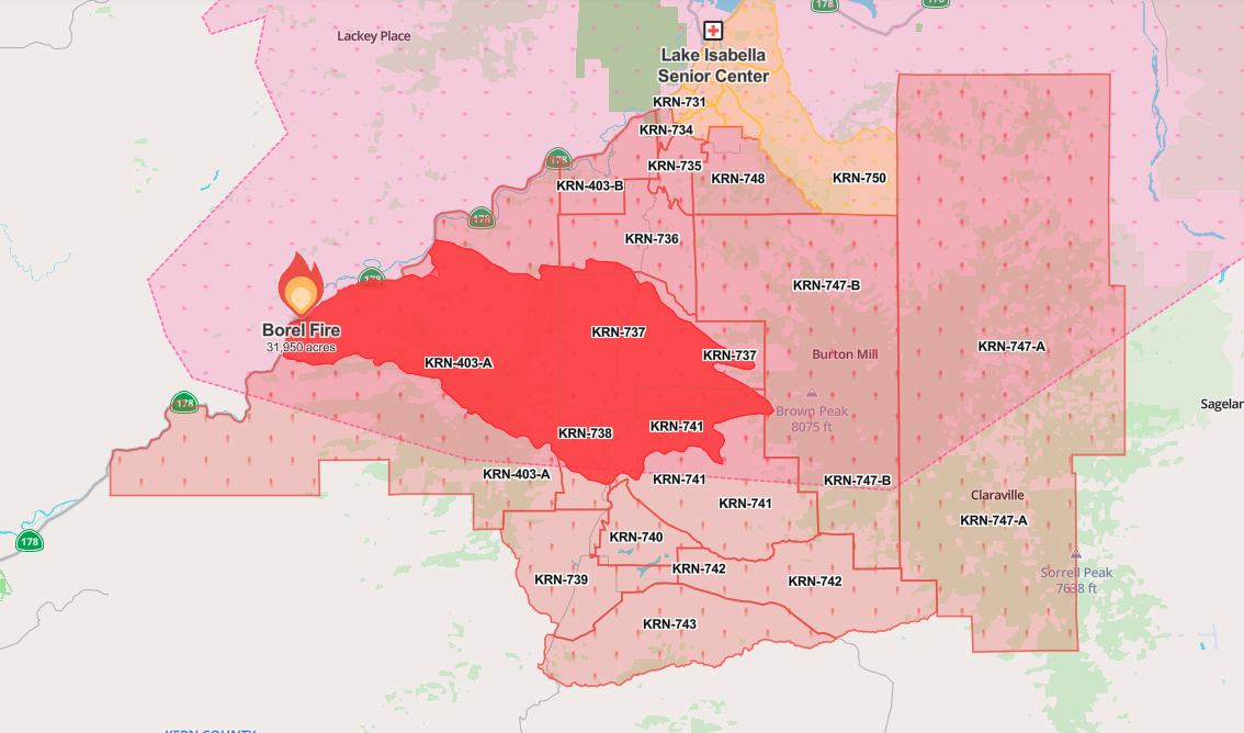
SATURDAY 7/27 UPDATE 1:
The Borel Fire is now listed as 31,950 acres burned according to the website Watch Duty.
Evacuation orders have expanded to:
KRN-734
KRN-735
KRN-738
KRN-747-A
KRN-748
Latest evacuation map per Watch Duty:
FRIDAY 7/26 UPDATE 3:
Neighborhood Reporter Corey O'Leary interviewed the Kern County Fire Department about the latest with the Borel Fire. Evacuation orders are still in place.
There are two evacuation centers open, one in Lake Isabella and one in Tehachapi.
WATCH THE LIVE INTERVIEW HERE:
FRIDAY 7/26 UPDATE 2:
More areas are being asked to evacuate due to the Borel Fire, which has now burned more than 12,000 acres.
Those include:
KRN-403-B
KRN-736
KRN-737
KRN-738
KRN-403-A

Check out this link for more information
WATCH TIMELAPSE VIDEO OF FIRE TAKEN FROM 23ABC ROOFCAM FROM FRIDAY AFTERNOON:
FRIDAY 7/26 UPDATE 1:
The Borel Fire has grown to nearly 8 thousand acres per the website Watch Duty. Evacuation orders are still in place. Highway 178 is still closed as crews work to fight the fire.
Latest evacuation map

THURSDAY 7/25 UPDATE:
Evacuation order has been issued for the areas around the Borel Fire. The fire has now burned more than 3,000 acres.
See map below:

Previous story:
Following a deadly crash in the canyon, which started a fire, Highway 178 is closed.
A crash was reported about 1 p.m. on Wednesday. The California Highway Patrol confirmed a vehicle drove off the road in the canyon and caught fire. They also confirmed at least one person died in the crash.
The highway has been closed since Wednesday afternoon.
According to reports on the Watch Duty website, the Borel Fire has burned more than 1,600 acres.
Evacuation warnings are in place south of Miracle Hot Springs and north of the mouth of the canyon (see map below):

Neighborhood Reporter Corey O'Leary is following the incident.
Stay in Touch with Us Anytime, Anywhere:


